What was the exact path of the Doolittle Raid?
score:10
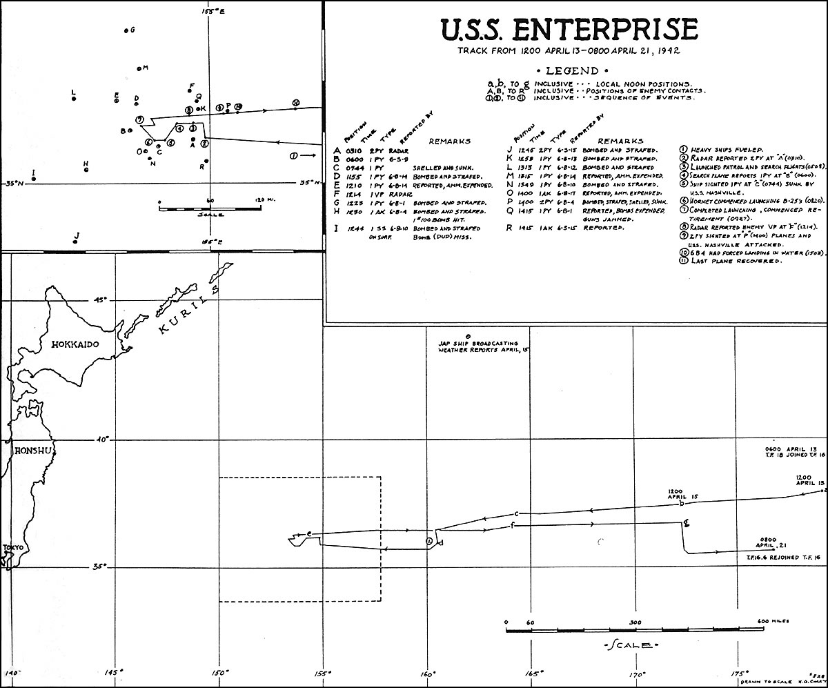
An action report for the Doolittle raid was prepared by Captain George D. Murray of the USS Enterprise (CV-6), and submitted to the Commander-in-Chief, U.S. Pacific Fleet, on 23 April 1942.
Most of what follows has been extracted from that report.
On 8 April 1942 Task Force Sixteen assembled at Pearl Harbor. The task force consisted of the USS Enterprise (CV-6, Flagship), USS Northampton (CA-26), USS Salt Lake City (CA-25), USS Balch (DD-363), USS Benham (DD-397), USS Fanning (DD-385), USS Ellet (DD-398) and USS Sabine (AO-25). Task Force Sixteen was commanded by Vice-Admiral W. F. Halsey, jr.
After landing the Air Group aboard south of Oahu the task force set a westerly, and then a northwesterly, course taking them 30 miles southwest of Nihoa Island.
This course (310° T) was continued with slight modifications until 0600 (Y) on 13 April, when they rendezvoused with Task Force Eighteen at position Latitude 38° 00' North, Longitude 180° 00'.
Task Force Eighteen consisted of the USS Hornet (CV-8, Flagship), USS Vincennes (CA-44), USS Nashville (CL-43), USS Gwin (DD-433), USS Grayson (DD-435), USS Meredith (DD-434), USS Monssen (DD-436) and USS Cimarron (AO-22). Details of the route taken by Task Force Eighteen can be found in the action report, submitted by Admiral Marc Andrew "Pete" Mitscher, of the USS Hornet.
USS Hornet carried the 16 B-25 bombers which would carry out the Doolittle Raid.
The two task forces merged under the designation Task Force 16, and set a course of 265° (T) and a speed of 16 knots towards Japan.
The heavy vessels refuelled on 17 April, when the task force was about 1000 miles east of Tokyo. When refuelling was complete, at 14:39 local time, the core of the task force (2 CV, 3 CA and 1 CL) set a westerly course and speed of approximately 20 knots towards the launch point.
The bombers were launched from the USS Hornet (CV-8) on 18 April between 08:20 and 09:21 local time, approximately 650 miles from Tokyo. The launches are recorded in the Deck Log of the USS Hornet. This would correspond with the approximate position you have of 35°N 154°E.
A comment on the action report notes that a track chart (Enclosure (A)), drawn to the scale of H.O. chart No. 528, was included with the report.

The original is presumably preserved in the US Navy Archives.
More post
- 📝 Did any country adopt a straight pull bolt-action rifle?
- 📝 What was the first recorded instance of burning a city or village in war?
- 📝 Will we ever get anything like the LBJ & Nixon White House recordings for contemporary presidents?
- 📝 To what extent was the Cold War caused by post World War 2 economics?
- 📝 Who is the earliest recorded person?
- 📝 Are there pictures expressing anti-occupation sentiment directed at British Forces in Germany before 1990?
- 📝 How did the US fall behind in airplane technology from 1909-1917?
- 📝 Was Pythagoras against traditional/contemporary Greek education?
- 📝 Why are the Corded Ware and Kurgan theories incompatible?
- 📝 Did the ancients or other pre-industrial civilisations engage in unsustainable practices?
- 📝 Why was the Western Front so static in World War I?
- 📝 What expenses did a village have?
- 📝 In a Nazi concentration, labor, or death camp, what was a "'sale' Appel"?
- 📝 Has a sovereign Communist government ever run, and conceded loss, on a fair election?
- 📝 Is there any history magazine like "Foreign Policy" for politics?
- 📝 Up to what levels were World War II commanders known for fighting at the battle front?
- 📝 What was the social status of a man who failed the civil service exams in Imperial China ( 1200 - 1800 AD )?
- 📝 Why did Iturbide choose Fernández for the mission to California?
- 📝 Three rings (wreaths?) symbol in XIX century Russia
- 📝 Scandal at Annapolis in 1934
- 📝 Was every man compelled to follow his father's occupation in ancient Egypt?
- 📝 Why is the USA the world's strongest country?
- 📝 Why was immigration from France to the United States lower than from some other countries?
- 📝 Did the Virginia pound use the pound sign (£)?
- 📝 Did the Greeks win the battle of Salamis because their rowers were "free"?
- 📝 Flag flying dynamics
- 📝 Lion in European monarchies' coats of arms
- 📝 Did Wright or Pickett set the high-water mark for the CSA Advance on Cemetery Ridge at Gettysburg?
- 📝 Did the Palmyrene Empire actually own territory beyond the Euphrates?
- 📝 Why did Ong Khan offer Temujin (young Gengis Khan) a position?
Source: stackoverflow.com
Search Posts
Related post
- 📝 What was the exact path of the Doolittle Raid?
- 📝 Did Adolf Hitler ever address the fact that his own appearance was almost an exact opposite of what he considered the ideal Aryan appearance?
- 📝 What was it like for a coastal village to experience a Viking raid in around the tenth century?
- 📝 What was the exact time of announcement of Indian independence?
- 📝 What was the historical context of the 2nd amendment to the US Constitution?
- 📝 During the breakup of the Soviet Union, on what basis was citizenship granted or withheld for each of the fifteen new republics?
- 📝 What was the typical peasant's diet like in Europe during the High Middle Ages?
- 📝 What led some people to (correctly) believe that there was no land under the ice cap at the North Pole?
- 📝 What was the status of Arab Christians during the crusades?
- 📝 What was the religion of the Arabic people before conversion to Islam?
- 📝 What was the purpose of Nazi extermination camps?
- 📝 What was the internal Soviet reaction to the moon landing?
- 📝 What was the function of the walls of Jericho?
- 📝 What was the pound (unit of weight) initially equal to?
- 📝 At what point was the Byzantine Empire's decline irreversible?
- 📝 What was the reason for Soviet troops to withdraw from Yugoslavia in World War II?
- 📝 What was the point of horse armour?
- 📝 What was the first solar eclipse that was demonstrably predicted in advance?
- 📝 What was the role of the Soviet Navy during WWII?
- 📝 What was the plan for an abort of the Enola Gay's mission to drop the atomic bomb?
- 📝 What was the economic basis for West Berlin?
- 📝 What is the evidence to claim that political order in ancient Rome was sufficiently different under "kingdom", "republic" and "empire"?
- 📝 What was the average height of Roman men and women?
- 📝 What was the longest a World War II submarine stayed at sea without being resupplied at a port?
- 📝 What was the cleanest war ever fought?
- 📝 What was the Seven Years War called at first?
- 📝 What was the first battle in history fought by vast-majority-% "distance-shooting" non-mechanized force?
- 📝 What / When was the first use of concentration camps in history?
- 📝 In which document was the exact course of the northern part of the German-Polish border decided?
- 📝 What was the ratio of German to Soviet losses on Eastern front during different stages of the war?